| |
|
|
| project results: |
Scale Space Hierarchy of Regions
Martin Drauschke
|
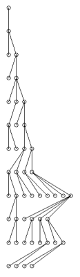
We build the Gaussian scale-space of the original image with
logarithmically ordered scales, cf. Drauschke et al. 2006. Each of the convolved
images decribes the image at one particular layer in the scale space. The
gradients are used as an input for a watershed algorithm that returns a
partitioning with regions for each layer of the image's scale-space. We define the
across-scale-neighbourhood by a region mapping, where we match a region of a layer
s to that region of layer s+1, which has the maximal overlap with the region of
layer s. Note that this asymmetric relation between two regions of different
scale-space layers does not depend on a threshold. However it not transitive,
thus we are not allowed to skip one scale layer.
We therefore obtain an image intrinsic graph structure which
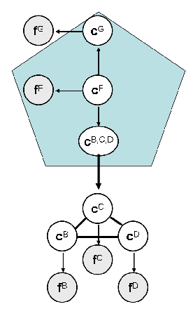
is a forest of trees and reflects the partonomy. This structure shall be used for
combining the compositional hierarchies of the classes in our ontology with the
interpretation of the segmented regions at a concrete scale. Let is take the
region F from the small example graph below: This region has been aggregated in
scale space from the regions B, C and D of the image layer below, and in the next
layer region F merges with region E to region G. Thus the extracted features and
/ or the classification results of the regions B,C,D and G shall be used for
improving the interpretation of region F. This is planned to be modelled by e.g.
a small Bayesian network with an integrated Hidden Markov Random Field.
|
|
References
| [1] |
Martin Drauschke, Hanns-Florian Schuster, Wolfgang Förstner,
Detectibility of Buildings in Aerial Images over Scale Space.
In: Wolfgang Förstner, Richard Steffen (Eds.), Symposium of ISPRS
Commission III - Photogrammetric Computer Vision, 20-22 September 2006,
Bonn, Germany, pages 7-12, 2006.
[pdf] |
|
|